

Zone 4: catchment du Cholet
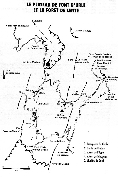
Zone 4: The Font d'Urle and Foret de Lente Catchment Area
Another vast and mostly heavily forested area which is very popular in winter with cross country skiing (and alpine skiing at Font d’Urle/Chaude Clapier). The main resurgence for this area is the Emergence du Cholet, a powerful resurgence situated at the head of the impressive Combe Laval gorge. Access is either a long walk from the nearest road head, or a 400 metre abseil from the over lying cliffs. To date, the resurgence has been pushed for some 1,731 metres to sump 4 by both local divers and members of UKs CDG with no conclusion. In the spring when the snow is melting, or during periods of prolonged heavy rain, large surface streams appear which drain into normally blind depressions (especially in the Lente area) indicating that there is still much to be discovered in this area.
The main feeder for the Emergence du Cholet is the Trou d’Anciens - Brudour - l'Appel -Toboggan system which drains the Font d’Urle highlands, whilst the Scialet Robin - Collecteur de la Vache system (see Scialet 36) resurges part way down the north side of Combe Laval
In contrast, the Font d'Urle plateau is completely different to Lente. The rolling, open grassland is very reminiscent of the Yorkshire Dales, with shake holes, collapses and open shafts everywhere (really!) Glaciere de Font d'Urle is evidence of an ancient phreatic system whilst Scialet Cloches provides the opportunity to descend an ice cave. The entire area is a cave diggers dream come true!
In recent years, the extension of Scialet II des Chauts to over 7,000m of mostly horizontal cave has been a spur to increased exploration in this area. There is even the possibility that Grotte de Berger could become a through trip via a surface shaft that is currently being pushed!
Significant caves of this area are:
· Reseau Christian Gathier A Vercors classic, entered either by Scialet du Toboggan or Scialet de Brudour. The system has been extended in recent years by the discovery of Trou d’Anciens which makes for a classic through trip, although you do need to understand how the lower part of the cave works in order to get out! The through trip should only be attempted in settled weather. . (See Speleo dans le Vercors Tome 1 and Vercors Caves – Des Marshall for detail).
· Scialet du Brudour GPS: 31T 683304E 4977237N(See Speleo dans le Vercors Tome 1 & Scialet No.5, 6, 9 & 14 & LSD No.3 for detail)
· Trou d’Anciens: GPS 31T 684368E 4973253N Discovered in 2001 (after many years prospecting) a series of pitches (and a meander) lead to -162m and the upstream Riviere de Montué. (See LSD No. 15 and Craven Pothole Club Record No. 96 for detail)
· Scialet de l’Appel: GPS 31N 683600E 4976169N A superb active river system, reached via an entertaining fossil entrance series – often ignored in favour of other trips. Avoid the active system in wet weather! (See Speleo dans le Vercors Tome 1 for detail)
· Grotte du Brudour: GPS 31N 683235E 4977202N Entrance is marked on the map. Explored by Martel in 1896, this fine horizontal resurgence cave is currently gated to protect the water which supplies St. Jean-en-Royans. (See Speleo dans le Vercors Tome 1 for detail)
· Glaciere de Carri: GPS 31N 686401E 4979279N Entrance is marked on the map. A great series of pitches in a descending rift to about -100m where it all gets a bit silly at a pendulum into a small passage and a squeeze beneath a large suspended boulder. Good for SRT practice, but can be cold. (See Speleo dans le Vercors Tome 1 & Scialet No. 10 for detail)
· Scialet des Meyniers: GPS 31N 683480E 4979864N Entrance is marked on the map. Initially quite scruffy until past the breakthrough squeeze – lots of moonmilk. (See Speleo dans le Vercors Tome 1 for detail)
· Scialet du Satyre: 836,50 X 3297,68 X 1135 GPS?? (See Speleo dans le Vercors Tome 1 & Scialet No.8, 9 & 19 for detail)
· Scialet Felix: GPS 31N 683480E 4979864N Entrance is marked on the map. Entrance pitch leads to a steep descent over forest (and farm) debris.(See Speleo dans le Vercors Tome 1 & Scialet No. 15 for detail)
· Grotte du Berger: GPS 31N 682496E 4973782N Entrance is marked on the map. The walk to the entrance is superb. A good horizontal trip for novices. Only slight problem being the (upwards) vertical squeeze not far from the entrance which may require assistance so take a short rope.(See Speleo dans le Vercors Tome 1 & LSD No. 1 for detail)
· Scialet Cloches: GPS 31N 684845E 4974083N Entrance is marked on the map. Entrance pitch leads to a steep snow slope into a large chamber decorated with ice formations.
· Scialet Robin: GPS 31N 685338E 4981616N Discovered in April 2006, a series of superb pitches to -187m lead to over 4k of well decorated passage – and the entrance is close to the road! (See LSD No. 16 for detail)
· Scialet II des Chauts: GPS 31N 684353E 4973265N. Extended in 2002. A 15m entrance pitch leads to over 12k of mostly horizontal passage, although the initial 2 hours is mostly crawling! Eventually the vast Garage a Boeing is reached with excellent formations in its many side galleries. In the centre of the Garage a Boeing is the Grand Noir, a 93m pitch which leads to the active part of the cave where exploration continues. (See LSD No. 15, 17 & 18 for detail)
· Glacier de Font d’Urle: GPS 31N 683397E 4973914N Entrance is marked on the map. Part of an ancient phreatic system which breaks surface in numerous place in Font’d’Urle. Part way through, on the left, is a descending passage into a large chamber where ice formation are sometimes found depending on the severity of the previous winter – frequently used by novice groups. There is an ongoing dig at the bottom of the chamber. (See LSD No. 16 for detail)
|
●
|
Scialet Veyou: GPS 31N 684623E 4973193N (aka Dead Deer Cave and Not the Dead Deer Cave) Difficult to find without GPS. 13m entrance pitch leads to short excavated crawl into a surprisingly large and well decorated chamber which used to contain the calcited skeleton of a deer (now removed for scientific study). See LSD 17 for details.
|
|
●
|
Scialet Comperes: GPS 31N 683938E 4972625N Could be the back door to Chuats II - see LSD 18 for details.
|
|
●
|
Scialet de la Porte Derobee: GPS 31N 683256E 4975555N Ongoing project currently -44 (See LSD 18 for details)
|
| News |
| SV Blog |
| Vercors Caving Log |
| Scialet du Combeau |
| SV Projects |
| Gouffre Berger |
| Grotte Roche |
| Scialet de la Jarjatte |
| Grotte Roche Gallery |
| Zone 1 |
| Zone 2 |
| Zone 3 |
| Zone 4 |
| Zone 5 |
| Zone 6 |
| Zone 7 |
| Zone 8 |
| Zone 9 |
| French Caving Terms |
| Via Corda |