

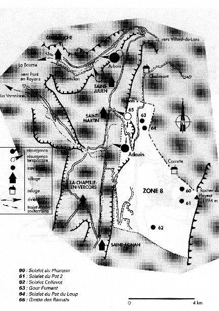
Zone 8: catchment de l’Adouin and the cuvette d’Herbouilly
Zone 8: The Herbouilly Plateaux and the Central High Plateaux Catchment Area
An interesting area hydrologically as it is situated between (and separate to) Zones 9 and Zone 6 both of which drain into the Bourne Gorge (Zone 6: Goule Verte – north and Zone 9: Source d’Arbois - south). The area is defined by two major faults, the southern limit being the fault at the Cabane de Tiolache and the northern limit being the fault of Carrrette.
It is currently the least understood catchment area of the Vercors, especially its southern boundary. The drainage of this area is to the valley and village of Tourtre (Source I'Adouin) which drains the Herbouilly Plateaux and the central High Plateaux (Purgatoire and Erges areas). This is interesting because it could represent an older period of drainage.
The current lack of hydrological knowledge for this area demonstrates that without the support of the local caving community, knowledge of karst drainage remains limited to speculation.
The Source l'Adouin catchment area is a rare and diverse landscape: the pastures of Herbouilly and Darbounouse, the vast area of lapiaz at le Purgatoire and Erges, the glacial valleys of Rey Blanc and du Pas Morta ...
The limestone at Herbouilly generally has low permeability, with surface flows sinking at small immature fissures. Gour Fumant and the Scialet Pot du Loup correspond to much older drainage systems.
The main source of capture for the Source l'Adouin is dominated by the huge areas of lapiaz (Roybon, Coinchette, le Purgatoire, les Erges ...). As one rises in altitude, the landscape is increasingly modeled by the Quaternary glaciers; limestone benches and glacial valleys. It is these valleys that should be the focus for future exploration. Apart from these valleys, glacial erosion contributed little to the karst landscape which could explain the lack of open shafts in this sector of the High Plateaux.
The entire area of le Purgatoire/Erges is extremely difficult terrain, which is why the main route north/south (GR91) dog legs around the area. It consists of numerous deep canyons on the wooded and steeply sloping hillside where it would be very easy to get lost. GPS is essential here and it is not the place for solo exploration (no mobile ‘phone coverage in this area). An injury, however minor, that incapacitates, could turn out to be lethal in this area.
Significant caves of this area:
· Scialet du Pharaon Like many caves on the Vercors High Plateaux, be sure you can find the entrance before the trip! (see Speleo Dans le Vercors Tome 2 & Scialet Nos 16 and 19 for detail)
· Scialet du Pot 2 A very difficult entrance to locate, Vercors Caves by Des Marshall has good directions (see Speleo Dans le Vercors Tome 2 & Vercors Caves for detail)
· Scialet Collavet Galerie des Merveilles is reported to be extremely well decorated. We have failed to find the entrance several times and do not believe that the directions in the book relate to those on the ground! (see Speleo Dans le Vercors Tome 2 & LSD No1 for detail)
· Gour Fumant GPS: 31N 694832E 4988695N Entrance is marked on the map. Has another entrance: Faux Gour – which some prefer. Nice series of pitches to –106, then a great horizontal section until the water becomes too deep, very few continue to the reputedly awful duck that leads to Reseau 1971 (see Speleo Dans le Vercors Tome 2 & Vercors Caves – Des Marshall & Scialet 26 for detail)
· Scialet du Pot du Loup GPS: 31N 694943E 4988299N Entrance is marked on the map. Despite it’s reputation as somewhere to take novices, this is actually a great trip, it’s a shame it suddenly ends at -94. (see Speleo Dans le Vercors Tome 2 & Vercors Caves – Des Marshall for detail)
· Grotte des Ramats GPS: 6938867E 4988669N Entrance is marked on the map. Proven hydrological connection to Gour Fumant, it responds rapidly to rain on the Herbouilly Plateaux and is therefore to be avoided in unsettled weather. Heavily used by novice groups as far as the sump. The climb to bypass the sump should be protected. Beyond the sump the cave is very different with potential for further exploration (see Speleo Dans le Vercors Tome 2 & Vercors Caves – Des Marshall for detail)
Some other caves in this area:
· Scialet Bleu An ancient horizontal phreatic system with several connections to the surface, still to find any of them! (see Speleo Dans le Vercors Tome 2 & Scialet No 15 for detail)
. Scialet Zakapouet: Location currently secret. Entrance is high on le Purgatoire. Currently -625m with open and ongoing exploration. Hopes that it could be the third -1,000m cave in the Vercors
· Scialet Gavet GPS: 31N 695057E 4988188N Entrance is marked on the map. Series of scruffy pitches to -70. (see Speleo Dans le Vercors Tome 2 for detail)
· Scialet de la Tronche 31N 701902E 4987799N Entrance (difficult to locate) marked on the map. Not sure why this is included in Zone 8 as it is located in Combe de l’Ours beneath the north face of the Grand Moucherolle. (see Speleo Dans le Vercors Tome 2 & Scialet No 19 for detail)
· Scialet des Trois Located some where in the lapiaz expanse of le Purgatoire. A fault controlled series of pitches to -135. The survey suggests that each pitch head is a funnel of loose boulders…(see Speleo Dans le Vercors Tome 2 & Scialet No 24 – the one with Hugh Penney on the cover)
· Grotte de la Cheminee GPS: 31N 694670E 4989574N Entrance is marked on the map. Heavily used by groups – large porch and descending passage to a large chamber with once impressive formations.
| News |
| SV Blog |
| Vercors Caving Log |
| Scialet du Combeau |
| SV Projects |
| Gouffre Berger |
| Grotte Roche |
| Scialet de la Jarjatte |
| Grotte Roche Gallery |
| Zone 1 |
| Zone 2 |
| Zone 3 |
| Zone 4 |
| Zone 5 |
| Zone 6 |
| Zone 7 |
| Zone 8 |
| Zone 9 |
| French Caving Terms |
| Via Corda |