

Zone 9: Catchment d’Arbois - Bournillon
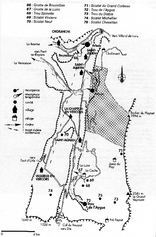
Zone 9: The Luire, Bournillon and Arbois Catchment Area
This area is by far the largest catchment area in the Vercors and is approximately 220 km2 (the Goule Noir catchment area is 60 km2). It covers the southern part of the Vercors High Plateaux (between Peyrouse-Sarna and Pre Peyret), Vassieux, the karst depression at Loscence, the Bois de 1'Allier and the edges of the depression of la Chapelle.
This karst drainage system is the third largest in France (based on the average of
7,8 m3/s), and is characterized by the total flooding of the system during periods of high water. The normal resurgence is the Sources de Arbois (a. 405 m) located in the lower Bourne Gorge. Its flow varies between 1,3 m3/s and 13 m3/s in high water (or up to
40 m3/s in exceptional flood). Once this outlet exceeds 3,5 m3/s, the Bournillon (a.
418 m and located further down the Bourne Gorge) starts to flow. Despite the temporary nature, this cave has an average flow of 3,8 m3/s (the same as the average of Arbois) and can evacuate as much as 80 m3/s!!! These floods (which are spectacular to witness) are usually caused by spring snow melt on the High Plateaux due to southerly winds loaded with moisture (but can also occur following protracted summer storms on the High Plateaux).
When the Bournillon reaches 40 m3/s, a further over-flow starts: the Grotte de la Luire. The Luire is not situated in the Bourne Gorge, but on the eastern flank of the Vernaison valley, twenty kilometers to the south of the Bournillon! Located at an altitude of 880m, that is, 475 m higher than the Sources de Arbois, the Luire in flood is a frightening sight, with flow rate of 60 m3/s!!!
There are a number of interesting caves on the High Plateaux but their development changes after about -300m from big shafts to tight rifts. There is still a huge amount of untapped potential on the High Plateaux though and it seems surprising that more prospecting is not carried out.
Significant caves of this area:
· Grotte de Bournillon GPS 691567E 4991843N The biggest cave entrance in Europe! Floods quickly following rain storms on the High Plateaux. Big, easy phreatic passage as far Village Negre. Watch out for opportunist car thieves at the parking area. (see Speleo Dans le Vercors Tome 2 & Vercors Caves – Des Marshall for detail)
· Grotte de la Luire GPS 691973E 4973754N Magnificent, complex and very underrated. Currently 581m vertical development and 44,100m horizontal development. Can flood very quickly! The entrance is a show cave and permission must be requested the day before your trip. During the summer, GSV will be working in the cave and the Grand Scialet will be rigged (100m abseil) for inbound cavers whilst exit is via the 67m Puits du Chat (fixed ladders). Try and arrange a trip with someone from the GSV to really get the best out of the cave (recommend either the Amont 1952 series or a visit to the down stream sump at -311m and very scary!) (see Speleo Dans le Vercors Tome 2, Vercors Caves – Des Marshall & Grotte de la Luire 1896-1996 2008 edition for detail)
· Trou Spinette GPS 31N 692957E 4972177N Entrance is marked on the map. Great series of pitches down to about -300m when it gets rifty. Hoped to be the “top entrance” to the Luire, but progress became difficult – still has depth potential. (see Speleo Dans le Vercors Tome 2 for detail)
· Scialet Vincens GPS 31N 693484E 4972867N Entrance is marked on the map. Great series of pitches down to about -300m when it gets rifty – still has depth potential. (see Speleo Dans le Vercors Tome 2 for detail)
· Scialet Neuf GPS: 31N 688654E 4977506N Entrance is marked on the map. Entrance pitch lands in chamber which used to contain good ice formations but not since the depth was extended from -50 to -385! (see Speleo Dans le Vercors Tome 2, “Speleos” No 87 & LSD No 10 for detail)
· Scialet du Grand Corbeau GPS 698427E 4976782N Entrance marked on the map. A 3 hour walk if you know where the entrance is! (high on the east Vercors ridge) Reported to be a good trip to -203 and Meander Bruno. (see Speleo Dans le Vercors Tome 2, Scialet No 5 and LSD No 1 for detail)
· Trou de l‘Aygue GPS 693028E 4969098N Both entrances marked on map. Fantastic through trip from E2 via P58 and great stream passage although exit should be checked out first! Now Closed. All entrances have been gated to protect the water which supplies St. Agnan. (see Speleo Dans le Vercors Tome 2, RHCC Journal No 7 1994, Speleo 42 & several Scialets and LSD for detail)
· Trou du Diable GPS 697663E 4969169N Entrance marked on map. Despite what it says in Speleo Dans le Vercors, it’s a long walk, and whilst the entrance is huge, it’s not easy to find unless you are standing next to it! (see Speleo Dans le Vercors Tome 2 for detail)
· Scialet Michellier GPS 687854E 4970738N Entrance: look for a covered manhole in a field 20m from the road. Three short pitches and a crawl lead to the wonderful P31 Puit du Silex and a further short crawl to a gallery with good mud formations. A fixed 7m rope leads to the well decorated Salle Sophie (great care required to avoid damage to formations) (see Speleo Dans le Vercors Tome 2 & CHV Journal No1 1966 for detail)
· Scialet Chassillan GPS: 31N 696398E 4973639N Best approached by descending past Scialet Combeau and then heading east up into Combe de la Siva (see separate SV report on Chassillan). An interesting entrance pitch of 38m between washed out shale beds leads to an ancient horizontal phreatic system with a number of blind shafts. (see Speleo Dans le Vercors Tome 2 & “Speleos” No 73 for detail)
Some other caves in this area:
· Scialet de la Grande Astrance GPS: 31N 693217E 4973422N Easy access, entrance marked on map, under a tree at the side of the road! Currently 163m deep and an ongoing “chemical dig” for GSV who hope to find the elusive “top entrance” to the Luire (see Speleo Dans le Vercors Tome 2, LSD No 3 & 17, RHCC Journal 1992 for detail)
· Scialet du Pichet GPS: 31N 695218E 4972796N Reports indicate it is horribly loose at -32 m and the anchors are awful! (see Speleo Dans le Vercors Tome 2 for detail)
· Perte des Sagnes GPS: 31N 688535E 4971214N Entrance is an active sink. Currently fenced off to keep children away – access may be refused. Entrance passage can sump, only descend in very settled weather, P31 reported to be fantastic! (see Speleo Dans le Vercors Tome 2 & CHV Journal No1 1966 for detail)
· Resurgence du Courant d’Air GPS 692713E 4969023N Only partially explored as it is highly flood prone. The entrance is part of a resurgence which drains Montagne de Beure. Over 700m of low crawling to the first boulder choke which is passed to a further choke at 1050m to the “Grand Salle ’64” and the vast “le Metro” where the way on is confusing. Real potential here, but very dangerous due to the potential of the first 1,000m to completely flood. (see Speleo Dans le Vercors Tome 2 for detail)
· Grotte Entre Ciel et Terre Entrance is part way down the eastern face of the Grand Veymont and involves a long walk and hairy abseil. (see Speleo Dans le Vercors Tome 2 & LSD No 11 for detail)
· Scialet du Combeau GPS: 31N 695222E 4974073N The only Vercors cave with ECO anchors. See elsewhere on this website for details
· Scialet des Drayes GPS: 31N 686319E 4973194N Entrance marked on map (in stand of trees below farm house) park before farm gate and do not obstruct track. 50m entrance pitch (rig from north side of shaft, use a deviation 3m down south side followed by a rebelay as it breaks into horizontal passage). 120m of horizontal passage includes easy crawl into good sized chamber with formations – good photo possibilities.
· Scialet Graille GPS: 31N 687058E 4982664N There is a very rough track which can be driven with care to a parking place at 31N 686823E 4982139N. Follow obvious path initially north and then north east up the side of the hill to the entrance. 10m entrance pitch to boulder slope down into large chamber with tatty formations. Scramble up on the left to second chamber with superb stal columns (take a camera). There is a further large chamber accessed via a hidden boulder choke. A good evening trip.
· Barme Chinelle GPS: 31N 691291E 4990325N Entrance marked on map. The entrance is near the top of a heavily wooded hillside and the map indicates that there are two paths leading to near the entrance. The southern path does not exist on the ground and whilst the northern path is good, it intersects with several other paths making for confusing route finding - it is unlikely that you will locate the entrance without GPS. Novice trip (much used by groups). Large descending passage leads via a hands and knees crawl into a chamber with good formations with good photo possibilities - look for the Victorian graffiti!
· Scialet Bidon GPS: 31N 689590E 4983443N Ongoing project in an interesting area. See LSD 18 for details
· Trou de Vent GPS: 31N 690949E 4985530N Ongoing project in an interesting area. See LSD 18 for details
| News |
| SV Blog |
| Vercors Caving Log |
| Scialet du Combeau |
| SV Projects |
| Gouffre Berger |
| Grotte Roche |
| Scialet de la Jarjatte |
| Grotte Roche Gallery |
| Zone 1 |
| Zone 2 |
| Zone 3 |
| Zone 4 |
| Zone 5 |
| Zone 6 |
| Zone 7 |
| Zone 8 |
| Zone 9 |
| French Caving Terms |
| Via Corda |