


An Overview of the Vercors
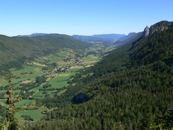
The Vercors National Park is a limestone plateaux some 50 miles (N/S)
by about 35 miles (E/W) and is located just south of Grenoble in the French
Alps. The main towns and villages are situated about 1000m ASL, whilst
the dramatic, unbroken east ridge peaks at 2341m ASL at the
Grand Veymont. Politically and commercially, the National Park is two
distinct areas separated by the Bourne Gorge. Whilst no where in the Vercors
can be considered overtly touristic, the north is more commercial and does
cater more for the tourist trade, mainly due to the importance of
Villard-de-Lans, Correncon , Meaudre and Autrans as major skiing resorts.
The countryside is also more dramatic than the south, with the magnificent
Grand Moucherolle (second highest peak in the Vercors) dominating the
skyline from just about anywhere. Whilst all towns and villages in the park have
their own local shopping, the only supermarket within the park is located in the
north (the Intermarche at Lans-en-Vercors which also has the cheapest fuel,
next door to Le Bricolage, the only DIY shed in the park, and really worth
wandering around).
In contrast, the southern Vercors is more rural, with villages catering more
for the local communities than tourists (so prices will be cheaper). The gentle
river valley of the Vernaison, contains the main villages of La Chapelle and
St Agnan, with La Chapelle being the main village in the south.
Most activities will also be primarily situated in either the north or south of the
park, so to cut down on driving (it can take an hour to drive from La Chapelle
to Villard for example - it's not the distance, but the nature of the roads!) it is
best to decide up front, whether you will base your stay in the north or the
south.
Getting There:
The most direct route is the motorway, which now starts at Calais docks.
A26 to St Quentin, Reims, Troyes. A5 to Langres. A31 to Dijon. A6 to
Lyon payage. Then immediately after the Lyon payage follow signs to Grenoble
and eventually the A48 (to Grenoble). For the north of the Vercors, leave the
motorway at the Grenoble payage and follow signs for Sassenage and
Villard-de-Lans (N532 and D531. For the south Vercors, take the A49
(direction Valence) before the Grenoble payage to Junction 9 (St. Romans and
Pont-en-Royans). Follow directions to Pont-en-Royans and then take the
D518 to La Chapelle-en-Vercors via the new tunnel at the head of the Grands
Goulets (about 40 minutes from Junction 9)
Maps:
The following three French IGN 1:25000 maps should suffice for a first visit:
3236 OT Villard-de-Lans
3136 ET Combe Laval
3235 OT Autrans
They are available mail order from Stanfords in London
Accommodation:
Nearly all villages have camp sites and gites and the local Tourist Information
office can provide details (main offices are in Villard-de-Lans and La Chapelle).
Generally prices will be cheaper in the south than in the north. From experience,
the best camp site in the south is Les Myrtille, just outside of La Chapelle,
which is a sheltered site with good facilities, a small snack bar and a free pool
(when the weather permits). La Chapelle is a good centre with a useful selection
of shops (including a good book shop for guide books) good bars, good food
shops and a sun trap swimming pool).
In the north, a popular camp site for visiting Brit cavers is l’Oursiere at Villard,
which is within easy walking of the shops and bars of Villard-de-Lans.
There are many gites in the Vercors and you should refer to the respective
Office of Tourism web sites for details.
SITE SEEING:
SHOW CAVES: (All French show caves give a "reduction pour le speleo").
The Choranche (in the Bourne Gorge) is one of the finest show caves you will
ever see. The Luirre, is interesting if you understand the hydrology of the
Vercors – it resurerges at the Bournillion. Draye Blanche is exceptionally and
surprisingly beautiful. Not quite a show cave, but an interesting afternoons
walk which you could combine with a visit to the Choranche show cave is the
Bournillion – the largest cave entrance in Europe. Continue down valley
(towards Pont) from the Choranche turning, and take the first turning on the left
(very sharp turn). Follow this narrow road (care) down into the valley, drive
through the water works, turn right and park in the lay bye on the left near the
Big Green Pipe. Then just follow the footpath that goes under the pipe.
On route to the cave entrance, you will have a superb view of the Moulin
Marquis waterfall, and canyon.
GORGES: You will not be able to avoid the Bourne Gorge and the Grand
Goulets (now sadly not so dramatic since the completion of the by-pass tunnel),
but an interesting car journey (if you are going to Expe) is to come
back via St. Gervais (north of Pont en Royans) and drive up past the Canyon
Ecouge – it’s a grade 5! And if you have a rainy day, why not drive down to
Die (famous for it’s market on Wednesday mornings) via the incredible
Col du Rousset. (If you park at the Rousset ski station, you can take the chair
lift up on to the Mountain du Beure where there are some fine views and a
table de Orientation.
THE RESISTANCE: Due to the fortress like nature of the Vercors, the local
Resistance, during WWII (March 1941 - August 1944), were able to defend
the Vercors for a long time. It was only after a massive parachute assault by the
Germans, that the Vercors finally fell. Because of the resistance put up by the
French, the Germans then proceeded to mercilessly bomb the place. They also
mercilessly butchered and tortured as many of the Resistance and their families
that they could find. Many of the Vercors roads pass through gorges and
cuttings. These places were "held" by the Resistance, and, by looking carefully,
plaques can be found, in memory of the men who were killed at their post. And
not only on roadsides. At several mountain passes, at a high level on many of
the ridges, again, plaques can be found.
A visit to the Musee de Resistance in the village of Vassieux can be a strange
experience. Even on a beautiful, hot, summer day, having been around the
museum, looking at the very graphic photos and displays, once outside, in the
sun, the whole place takes on a cold, sinister atmosphere. There is now a new
museum on the pass above Vassieux, which is an equally moving experience.
A visit to Valchevriere, (on the Herbouilly road between St Martin and
Villard-de-Lans) a village bombed by the Germans, is another strange
experience. The village was not rebuilt, it is still in ruins. Only the church has
been restored. If you look very carefully, you'll still see signs that people lived
And worked there.
WARNING:
The Vercors National Park is an area of outstanding natural beauty.
Unfortunately, that means nothing to opportunist car thieves. Whilst not as
prevalent as other areas of Europe, stealing from cars is on the increase.
Prime areas for increased awareness (although not confined to) are those
remote places where cars are left unattended whilst their owners are
walking or caving, such as the Herbouilly Plateau, parking areas in the
Bourne Gorge, the parking area at la Coche (for the Grand Veymont) and
the Montagne de Beure car park behind Rousset. Most thieves seem only
interested in money rather than equipment. The best way of avoiding a
break in is to
LEAVE NOTHING IN YOUR CAR
| News |
| SV Blog |
| Vercors Caving Log |
| Scialet du Combeau |
| SV Projects |
| Gouffre Berger |
| Grotte Roche |
| Scialet de la Jarjatte |
| Grotte Roche Gallery |
| Zone 1 |
| Zone 2 |
| Zone 3 |
| Zone 4 |
| Zone 5 |
| Zone 6 |
| Zone 7 |
| Zone 8 |
| Zone 9 |
| French Caving Terms |
| Via Corda |